Be it the effects of climate change or La Niña, 2022 has seen many densely populated areas of Australia inundated with extreme flooding events. Spatial Vision’s award winning mapping and analysis work for E2DesignLab, Melbourne Water and affected councils in the flood prone Elster Creek catchment zone charts a course for similar vulnerable areas.
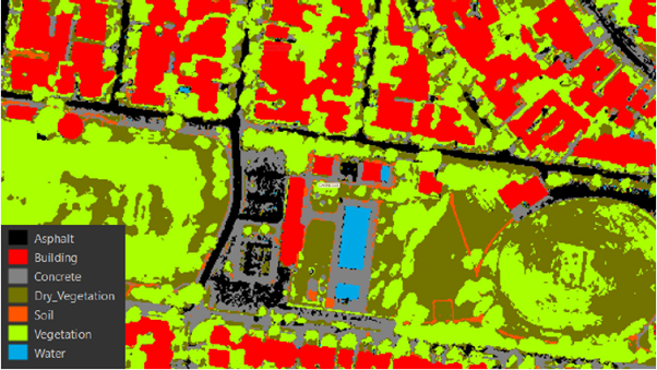
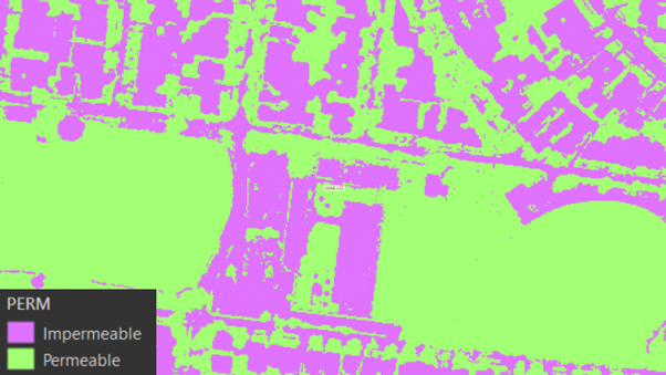
High permeability reduces flood risk and increases stormwater quality, urban greening and amenity. An innovative approach was required to spatially map surface permeability on behalf of Elster Creek Catchment Flood Management Plan Working Group. The principal benefit for participating councils was a complete and detailed permeability analysis for the entire catchment to support better decision making and future modelling.
A key focus of permeability mapping is to provide local government with a tool that can support water-sensitive urban design (WSUD) planning for the public realm, and development control for the private realm, thus minimising stormwater run-off and flood risk.
Executed over 13 months, this Elster Creek Catchment Flood Management Plan Working Group funded project met three key land use planning deliverables for their flood management plan:
- A catchment-wide GIS dataset in a vector format for permeability and surface type
- Detailed attribution including confidence level, data source and other key information
- A variety of summary tables and mapping outputs for reporting and presentation

")