Permeability Partnership Wins Stormwater Award
")
A Spatial Vision collaboration with E2Designlab and Hansen Partnership to complete a permeability research project for City of Port Phillip has been ‘Highly Commended’ at Stormwater Victoria‘s Awards for Excellence.
The City of Port Phillip is characterised by generally flat terrain less than a few metres above sea level. Meanwhile, high urban development in Port Phillip often mitigates the underlying soil’s capacity to absorb water. Combined with other factors at play including high tides, pipe blockages and floods associated with intense rainfalls, the risk to homes and businesses in the City of Port Phillip is more apparent than many Melbourne municipalities.
High permeability provides several benefits, including reduced flood risk, improved stormwater quality, increased urban greening and amenity. The use of water-sensitive urban design (WSUD) and permeability responses in developed areas also provides a means to increase infiltration and water reuse whilst decreasing stormwater runoff.
A rigorous and repeatable methodology was employed to map existing permeability across urban catchments to enable a technical assessment of flood responses. Approaches for measuring the benefits provided by WSUD responses was also undertaken.
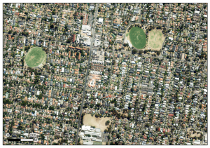
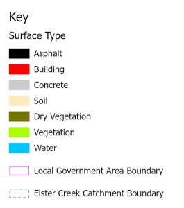
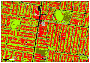
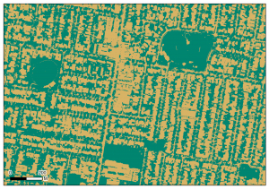
With E2Designlab’s guidance, Spatial Vision developed a rules-based approach to systematically classify and map data between spatial elements, LiDAR returns and multispectral aerial imagery. An ESRI GIS geodatabase mosaic layer was produced depicting various surface types and permeable or non-permeable areas, in addition to fraction mapping and vegetation mapping (see below).
For the City of Port Phillip, measuring the extent to which WSUD mimics permeability and contributes to a more effective stormwater system derived multiple stormwater management and climate resilience outcomes, including;
- A clearly articulated definition of permeability, and permeable equivalence, that reflected Council’s stormwater and climate resilience objectives
- Identification of permeability opportunities and constraints
- Development of a rules-based approach to systematically classify and map data between spatial elements, LiDAR returns and aerial multispectral imagery, including impervious fraction mapping and vegetation mapping
- A technical assessment of suitable permeability responses and approaches for the quantification of benefits provided by WSUD responses
- Spatial mapping of permeability to measure interventions over time
- Recommendation of appropriate planning and policy interventions to deliver permeability objectives
Stormwater Victoria, which represents organisations and individuals involved in stormwater flow, environmental quality and use, recognised this project for the valuable contribution it will make to their sector. Other local government areas facing similar issues may also benefit from this work in the future.
For more information, please get in touch