“The work we are doing on the DCM project has never been done before leaving an open door for innovation, problem solving, and the delivery of a world leading product. With a strong appreciation for the Victorian cadastre, this is our contribution to supporting its development, while leaving a legacy.”
–Cameron Hamilton, DCM Adjustment Team Leader
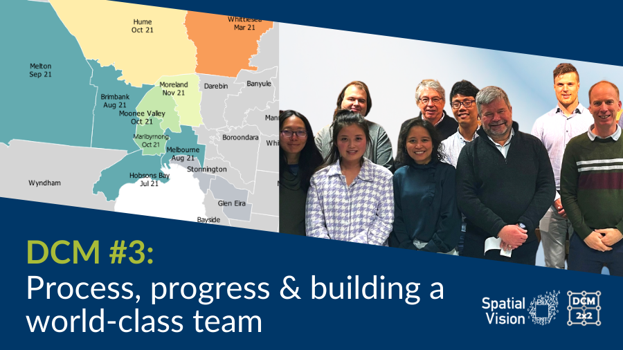
Great strides for DCM
It has been a huge six months for the team working on Digital Cadastral Modernisation (DCM) at Spatial Vision. This time has seen us increase our capacity and throughput via a series of improvements in project management, processes and production tools and a strong investment in staff.
Managing Director Glenn Cockerton says of the project, “The capabilities that the Spatial Vision team, supported by our colleagues at Reeds Consulting and Collier Geodetic Services, have brought to bear for this most challenging project have been nothing short of outstanding. One of Spatial Vision’s most significant projects, this work will be recognised in the future for both its technical sophistication and the quality of delivered product. The State of Victoria will benefit from the DCM project investment for decades to come.”
Progress to date
The maps below indicate completion dates and the time spent on each LGA. Of the LGAs we have completed, the largest is the City of Greater Geelong (36,215 individual survey plans across 1491 cadastral blocks, the smallest is the City of Melton (6380 plans across 230 blocks).
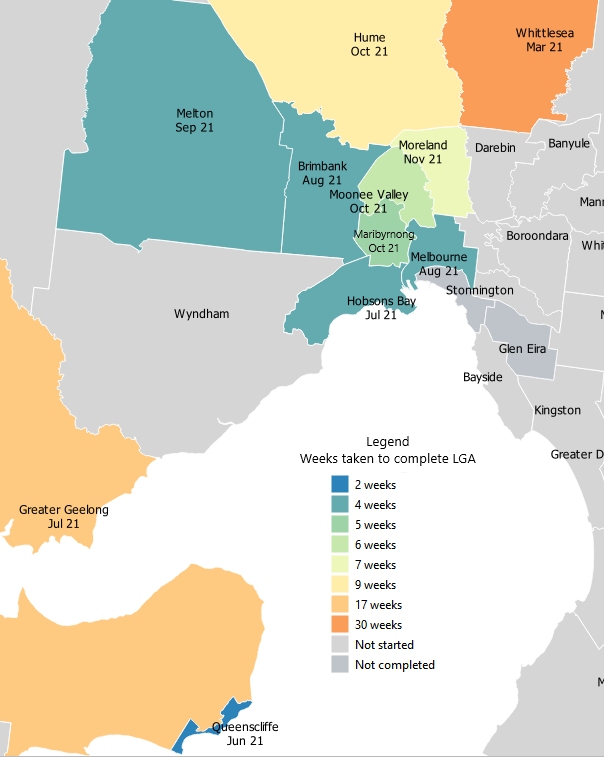
Pictured: Map showing delivered LGAs, time taken to complete the LGA and delivery month
Improved quality and production monitoring
In April 2021, Spatial Vision appointed Ryanne Firme as the DCM project’s Production Manager and Stephen Boothroyd as the Quality Manager. These two individuals provided strong survey project management skills which complemented the skills of our Cadastral partner Reeds Consulting, our geodetic specialist Phil Collier, and the project Team Leaders. The addition of Ryanne and Stephen to the team provided a foundation for subsequent project improvements and enabled us to focus on streamlining specific project areas including quality and production monitoring.
New process improves throughput by 400%
The DCM adjustment stage presented several challenges from day one, including complex work and tight timeframes. The slow start up was not unexpected and the requirements for researching the many and varied survey plans provided a substantial learning curve before we could begin producing the best fit within a least squares adjustment.
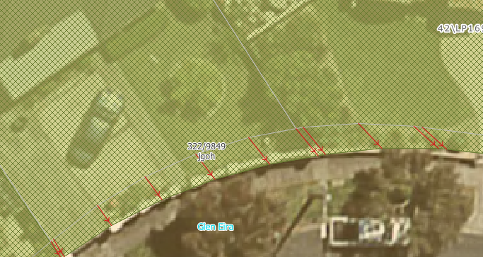
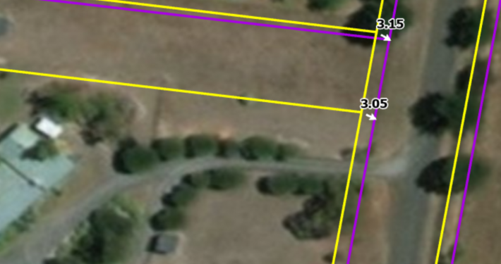
Pictured: The change in Vicmap parcel boundaries, shown in white following the adjustment. The red shift vectors are a key deliverable that show the direction and magnitude shifts to parcel nodes post adjustment.
To speed up delivery, in May 2021 the Adjustment team began a process of ‘time-boxing’ the effort of adjustment operators. This began at 60 minutes for each cadastral block processed. Blocks that could not be completed within the allotted time were reviewed and a decision was made to either allow limited additional time to complete the block, or pass it on to a more experienced operator to complete.
The 60-minute period was soon reduced to 30 minutes and, after testing and refinement, the revised process was rolled out across the entire team. The number of plans within a cadastral block is a good indicator of block difficulty, and while the initial block size was relatively small, comprising around thirty plans we now regularly completing blocks with twice that number within the allotted time. Importantly, the quality of the DCM Adjustment outputs has not been reduced, as much of the ‘grunt work’ of plan research has been replaced by improved processing techniques/tools, and increased knowledge and experience within our team.
Improved automation delivers quality and efficiency
The DCM adjustment technical development team are the engine room behind many of the productivity increases that Spatial Vision has been able to achieve. Helping the development team is Phil Collier, one of the developers of DynAdjust – the least squares software used to complete the least squares adjustment process. Phil enjoys the challenge of applying mathematical rigour to process changes, ensuring that improvements are not made at the expense of quality.
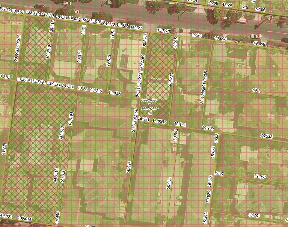
Pictured: Backcaptured parcel distance data used as an input to the adjustment
With Phil’s advice, our hardworking and creative development team have implemented a wide range of improvements to our adjustment process tools. The main effort has been devoted to improving the automation of the adjustment process so that the time spent on blocks by adjustment operators is minimised, but substantial improvements have also been made to our data delivery, project management and reporting tools.
Building a world-class team
Despite the many technical and process improvements, in the end, each cadastral block adjustment needs to be completed by an individual.
Over the past 18 months, Spatial Vision has built and trained a team of highly competent adjustment operators and team leaders from scratch, and, due to COVID, largely in a distributed work environment. The team has proven to be truly agile, not only in their ability to adapt to changing software and processes but to help identify changes to our toolkit and approach enabling us to continue to increase throughput and improve the quality of the adjusted data we deliver.

Image: Members of the DCM team

“The people at Spatial Vision have created a work culture that is based on genuine care and kindness towards individuals and the greater community, changing the world for the better with critical thinking and innovative solutions.”
–Zoltan Goblos, DCM Adjustment Team Leader
What’s next?
Spatial Vision will continue to grow our adjustment team with additional staff in due to commence in November, and a second intake to begin in January. We look forward to onboarding more industry talent to deliver a quality outcome for this ground-breaking project.
For more information about DELWP’s DCM project, visit: land.vic.gov.au/surveying/projects-and-initiatives/digital-cadastre-modernisation/about-the-project
Learn more about our Digital Cadastre Transformation services here.
Jeremy’s role includes distributing and value-adding spatial data, identifying and locating spatial datasets for a variety of clients and purposes, and cleaning and restructuring data to meet client’s business needs. He has extensive experience in managing large data capture and conversion projects. Jeremy adopts spatial industry best practice for managing and distributing spatial data and contributes to consultancies requiring specialist input on the acquisition and management of spatial data.
- DCM #3: Process, progress & building a world-class team - November 17, 2021
- DCM #2: Adjusting Cadastral Surveys using DynAdjust - October 26, 2020
- DCM #1: Preparing for DCM2x2 - June 19, 2020
 https://spatialvision.com.au/wp-content/uploads/2022/09/DCM-example.png
914
1371
Samantha Sinclair
https://spatialvision.com.au/wp-content/uploads/2020/04/SV_Logo_Inline.png
Samantha Sinclair2024-07-23 04:37:162024-07-23 16:37:11Digital Cadastre Modernisation
https://spatialvision.com.au/wp-content/uploads/2022/09/DCM-example.png
914
1371
Samantha Sinclair
https://spatialvision.com.au/wp-content/uploads/2020/04/SV_Logo_Inline.png
Samantha Sinclair2024-07-23 04:37:162024-07-23 16:37:11Digital Cadastre Modernisation https://spatialvision.com.au/wp-content/uploads/2023/08/Case-Study-web-tile.png
500
900
Samantha Sinclair
https://spatialvision.com.au/wp-content/uploads/2020/04/SV_Logo_Inline.png
Samantha Sinclair2023-09-11 09:20:262023-12-20 11:04:32Case Study: Victoria’s Digital Cadastre Modernisation
https://spatialvision.com.au/wp-content/uploads/2023/08/Case-Study-web-tile.png
500
900
Samantha Sinclair
https://spatialvision.com.au/wp-content/uploads/2020/04/SV_Logo_Inline.png
Samantha Sinclair2023-09-11 09:20:262023-12-20 11:04:32Case Study: Victoria’s Digital Cadastre Modernisation https://spatialvision.com.au/wp-content/uploads/2023/05/DC-award-scaled.jpg
1707
2560
Samantha Sinclair
https://spatialvision.com.au/wp-content/uploads/2020/04/SV_Logo_Inline.png
Samantha Sinclair2023-05-12 12:16:012023-12-20 11:02:45Spatial Vision takes out national APSEA Award
https://spatialvision.com.au/wp-content/uploads/2023/05/DC-award-scaled.jpg
1707
2560
Samantha Sinclair
https://spatialvision.com.au/wp-content/uploads/2020/04/SV_Logo_Inline.png
Samantha Sinclair2023-05-12 12:16:012023-12-20 11:02:45Spatial Vision takes out national APSEA Award https://spatialvision.com.au/wp-content/uploads/2022/11/DCM-Blog-Covers-3.png
506
900
Samantha Sinclair
https://spatialvision.com.au/wp-content/uploads/2020/04/SV_Logo_Inline.png
Samantha Sinclair2022-11-25 16:01:272023-12-20 11:14:02Are you ready for DCM?
https://spatialvision.com.au/wp-content/uploads/2022/11/DCM-Blog-Covers-3.png
506
900
Samantha Sinclair
https://spatialvision.com.au/wp-content/uploads/2020/04/SV_Logo_Inline.png
Samantha Sinclair2022-11-25 16:01:272023-12-20 11:14:02Are you ready for DCM? https://spatialvision.com.au/wp-content/uploads/2022/10/SV-wins.jpg
800
1200
Samantha Sinclair
https://spatialvision.com.au/wp-content/uploads/2020/04/SV_Logo_Inline.png
Samantha Sinclair2022-10-28 15:40:132023-12-20 11:15:07Spatial Vision on the double at Vic APSEA Awards
https://spatialvision.com.au/wp-content/uploads/2022/10/SV-wins.jpg
800
1200
Samantha Sinclair
https://spatialvision.com.au/wp-content/uploads/2020/04/SV_Logo_Inline.png
Samantha Sinclair2022-10-28 15:40:132023-12-20 11:15:07Spatial Vision on the double at Vic APSEA Awards https://spatialvision.com.au/wp-content/uploads/2022/07/DCM-Blog-4.png
497
885
Samantha Sinclair
https://spatialvision.com.au/wp-content/uploads/2020/04/SV_Logo_Inline.png
Samantha Sinclair2022-08-08 09:49:112023-12-20 11:16:15The DCM Project – Correctly Delivering Everyone’s Parcels
https://spatialvision.com.au/wp-content/uploads/2022/07/DCM-Blog-4.png
497
885
Samantha Sinclair
https://spatialvision.com.au/wp-content/uploads/2020/04/SV_Logo_Inline.png
Samantha Sinclair2022-08-08 09:49:112023-12-20 11:16:15The DCM Project – Correctly Delivering Everyone’s Parcels https://spatialvision.com.au/wp-content/uploads/2021/10/DCM-Readiness-Index.png
1124
1148
Samantha Sinclair
https://spatialvision.com.au/wp-content/uploads/2020/04/SV_Logo_Inline.png
Samantha Sinclair2022-03-18 10:34:012023-12-20 11:16:56Vicmap Users to Benefit from New DCM Tools & Resources – Digital Cadastre Modernisation (DCM)
https://spatialvision.com.au/wp-content/uploads/2021/10/DCM-Readiness-Index.png
1124
1148
Samantha Sinclair
https://spatialvision.com.au/wp-content/uploads/2020/04/SV_Logo_Inline.png
Samantha Sinclair2022-03-18 10:34:012023-12-20 11:16:56Vicmap Users to Benefit from New DCM Tools & Resources – Digital Cadastre Modernisation (DCM) https://spatialvision.com.au/wp-content/uploads/2021/11/DCM-Blog-3-Cover.png
506
900
Jeremy Alcorn
https://spatialvision.com.au/wp-content/uploads/2020/04/SV_Logo_Inline.png
Jeremy Alcorn2021-11-17 12:30:472023-12-20 11:17:48DCM #3: Process, progress & building a world-class team
https://spatialvision.com.au/wp-content/uploads/2021/11/DCM-Blog-3-Cover.png
506
900
Jeremy Alcorn
https://spatialvision.com.au/wp-content/uploads/2020/04/SV_Logo_Inline.png
Jeremy Alcorn2021-11-17 12:30:472023-12-20 11:17:48DCM #3: Process, progress & building a world-class team https://spatialvision.com.au/wp-content/uploads/2021/05/Ryanne-Featured-Image-1.png
862
1384
Spatial Vision
https://spatialvision.com.au/wp-content/uploads/2020/04/SV_Logo_Inline.png
Spatial Vision2021-05-21 14:27:362023-12-20 12:05:53Welcome Ryanne Firme – Digital Cadastre Modernisation Team
https://spatialvision.com.au/wp-content/uploads/2021/05/Ryanne-Featured-Image-1.png
862
1384
Spatial Vision
https://spatialvision.com.au/wp-content/uploads/2020/04/SV_Logo_Inline.png
Spatial Vision2021-05-21 14:27:362023-12-20 12:05:53Welcome Ryanne Firme – Digital Cadastre Modernisation Team https://spatialvision.com.au/wp-content/uploads/2021/04/stephen-welcome-featuredimage.png
862
1384
Spatial Vision
https://spatialvision.com.au/wp-content/uploads/2020/04/SV_Logo_Inline.png
Spatial Vision2021-04-13 14:59:262023-12-20 12:06:08Welcome Stephen Boothroyd – Digital Cadastre Modernisation Team
https://spatialvision.com.au/wp-content/uploads/2021/04/stephen-welcome-featuredimage.png
862
1384
Spatial Vision
https://spatialvision.com.au/wp-content/uploads/2020/04/SV_Logo_Inline.png
Spatial Vision2021-04-13 14:59:262023-12-20 12:06:08Welcome Stephen Boothroyd – Digital Cadastre Modernisation Team https://spatialvision.com.au/wp-content/uploads/2020/10/DCM-Blog-Cover-2.png
506
900
Jeremy Alcorn
https://spatialvision.com.au/wp-content/uploads/2020/04/SV_Logo_Inline.png
Jeremy Alcorn2020-10-26 15:55:502023-12-20 12:08:52DCM #2: Adjusting Cadastral Surveys using DynAdjust
https://spatialvision.com.au/wp-content/uploads/2020/10/DCM-Blog-Cover-2.png
506
900
Jeremy Alcorn
https://spatialvision.com.au/wp-content/uploads/2020/04/SV_Logo_Inline.png
Jeremy Alcorn2020-10-26 15:55:502023-12-20 12:08:52DCM #2: Adjusting Cadastral Surveys using DynAdjust https://spatialvision.com.au/wp-content/uploads/2020/06/BlogCover1.png
506
900
Jeremy Alcorn
https://spatialvision.com.au/wp-content/uploads/2020/04/SV_Logo_Inline.png
Jeremy Alcorn2020-06-19 17:45:232023-12-20 12:10:53DCM #1: Preparing for DCM2x2
https://spatialvision.com.au/wp-content/uploads/2020/06/BlogCover1.png
506
900
Jeremy Alcorn
https://spatialvision.com.au/wp-content/uploads/2020/04/SV_Logo_Inline.png
Jeremy Alcorn2020-06-19 17:45:232023-12-20 12:10:53DCM #1: Preparing for DCM2x2 https://spatialvision.com.au/wp-content/uploads/2020/06/dcm.jpg
540
960
Spatial Vision
https://spatialvision.com.au/wp-content/uploads/2020/04/SV_Logo_Inline.png
Spatial Vision2020-06-16 13:51:002023-12-20 12:11:13Spatial Vision to Play a Key Role in Victoria’s Digital Cadastre Modernisation
https://spatialvision.com.au/wp-content/uploads/2020/06/dcm.jpg
540
960
Spatial Vision
https://spatialvision.com.au/wp-content/uploads/2020/04/SV_Logo_Inline.png
Spatial Vision2020-06-16 13:51:002023-12-20 12:11:13Spatial Vision to Play a Key Role in Victoria’s Digital Cadastre Modernisation
