Fascinating but worrying to see the work reported in The Age Newspaper (“Great Ocean Road at risk from surging sea” 11/01/2019 – Royce Millar) concerning the impact of rising sea levels on the iconic Great Ocean Road along the south-western Victorian coastline. The article indicates that there are great concerns of continued sea level rise and erosion impacts washing away major sections of the Great Ocean Road in and around the Apollo Bay region.
As reported in the article
“New studies of dramatic beach erosion around Apollo Bay over the last two years highlight the mounting problem of erosion, flooding and sea level rise along Victoria’s coast”.
The study findings relate very closely to the work Spatial Vision undertook with the Biodiversity team at the Department of Environment, Land, Water and Planning (the “Coastal Climate Change Impact Assessment”) in 2017. This state-wide study modelled the likely impacts of anticipated climate change along the Victorian coastline in terms of both coastal erosion and inundation. And was the first state-wide study of this type. This study was undertaken to support the focussing of monitoring efforts along the coast – the Victorian Coastal Monitoring Program

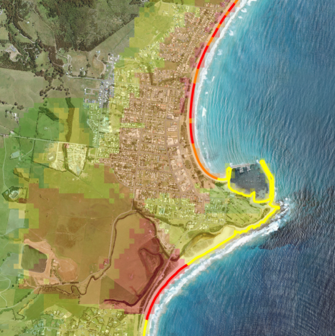
Image: Modelling of impacts of anticipated climate change along the Victorian coastline
Both studies (the recent Neville Rosengren and Tony Miner one Royce highlights, and the Spatial Vision/DELWP one) identify the key concerns around the Mounts Bay / Marengo Beach area to the south of Apollo Bay Township, which from 2017 saw massive coastal erosion issues that required intervention and beach re-nourishment. Other areas identified in both studies along that part of the Great Ocean Road include beaches to the north of Apollo Bay and around the Tuxion Road carpark (which all rated a Very High Coastal Erosion vulnerability rating in the SV/DELWP study).
Although the SV/DELWP study comprised a high-level state-wide modelling approach based on spatially defined coastal erosion risk factors relating to exposure, sensitivity and adaptive capacity of the coast, the correlations with Rosengren & Miner and GHD engineering investigations are striking.
In a follow up article in The Age over the weekend (“Oceans rising: can we save our collapsing coastline?” 12/01/2019 Royce Millar & Benjamin Preiss), discussion centred on the coastlines and foreshores in a broader number of key tourist hot spots along the Victorian coast. These included Venus Bay, Cowes foreshore on Phillip Island, Inverloch and the beaches on the eastern part of Port Phillip Bay between Frankston and Mentone. These popular beach areas, like those identified around Apollo Bay, are facing increasing erosion risk from a rising sea level and coastal inundation. All are seeing the beaches and coastal features that make them unique and draw people disappearing or degrading over time. These and other areas, in addition to those along the Great Ocean Road near Apollo Bay, are also identified in the SV study identified as having high to very high erosion vulnerability.
For further details on the Spatial Vision/DELWP study see our earlier article featuring a video of the project or read the case study.
Also worth noting that a statewide coastal monitoring program supported by the Spatial Vision/DELWP study is contributing to a broader global oceans monitoring effort. And that today it was reported that a new study using this information has found the oceans are warming much faster than previously thought. Ocean temperature has a significant impact on the climate systems, in addition to warmer oceans meaning the sea levels rise is likely to occur faster than the current models suggest.
For further information, please contact Spatial Vision https://spatialvision.com.au/contact/
Further reading: Coral Reef Crisis Guide
Harmen is a skilled analyst and modeller with over 6 years of experience in Geospatial Analysis.He has a strong background in the ArcGIS environment, Python scripting and the application of automation in modelling processes for large datasets and series.This has most recently been applied in the evaluation and processing of environmental works program data across Victoria for the analysis of works size and alignment to best management practices.
- When to Raster vs When to Vector? A worked example - May 4, 2022
- Mapping the Future of Farming - August 9, 2019
- Great Ocean Road Erosion Impacts - January 10, 2019