As part of my Cadetship at Spatial Vision, I designed and delivered an R&D project. After plenty of research, I chose to explore KNIME’s functionality, and how it can be applied within Spatial Vision. KNIME is a workflow based data transformation, analysis and deployment program. Developed in Java using Eclipse as a free open source program, users are able to modify the base code of the program to suite their individual needs, allowing the creation of plugins to expand the functionality of KNIME.
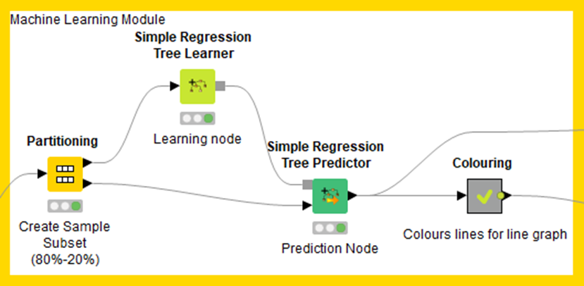
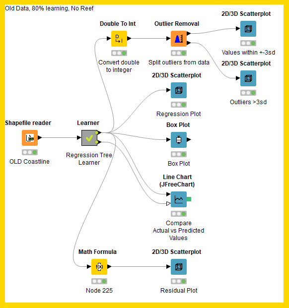
KNIME uses ‘Nodes’ to represent an input, process or output. These nodes once connected to one another form a workflow. Nodes are typically classified into 6 different categories based upon their purpose.
- Data Access Nodes
- Big Data Nodes
- Transformation Nodes
- Visualization Nodes
- Deployment Nodes
- Analysis Nodes
Analysis and Data Mining
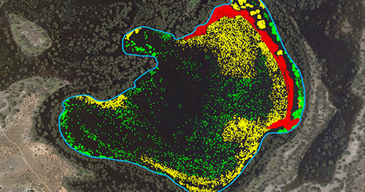
Analysis and Data Mining is the other prime function of KNIME that really gives it an edge in terms of functionality. Examples of these include advanced statistics, imagery analysis, web analytics, text mining, social media analysis and machine learning based prediction modelling.
One of the key factors that makes KNIME so valuable is its ability to package up a workflow and distribute it to other users. Inclusion of input data and any wrapped meta-nodes is also an option during exporting. Workflows are small files and only become large if the input data is included. If the recipient of the workflow has the same data then all they need to do is point the input node to their data location, hit run and the process would work identically.
Overall, I have found KNIME to be a highly adaptable and valuable program. It has the capacity to not only improve workflow methodologies but to also provide a mechanism for distribution of these workflows to clients, colleagues and affiliates. At this stage KNIME is not a perfect fit for spatial data sources so its use within Spatial Vision is limited however, the real value in KNIME is its machine learning capacity and ability to produce not only analytical results but drive innovation, integration and evolution of ideas to refine and improve upon existing and future methodologies. KNIME is the type of program that is a real jack-of-all-trades and a master of none (to an extent). This gap however is not exactly a weakness of the program itself but more of an opportunity for private developers to create their own nodes and tools to customise and improve the program to their own benefit.
For further information, please contact Spatial Vision at info@spatialvision.com.au
- Case Study: GIS Service Plan - July 24, 2024
- Climate Change Statement - November 9, 2021
- Welcome Ryanne Firme – Digital Cadastre Modernisation Team - May 21, 2021