The first data from the 2016 Census has just been released so it’s important to take time to understand the different geographies used by Australian Bureau of Statistics (ABS) and what data is being released for each of them.
ABS Geographies
The ABS have a series of unique spatial boundaries in which data is collected, analysed and released in. Even though data is collected at the household level on census night, that level of detail is generally not available. This is to protect the individual as we know there is a lot of personal and financial information collected. In addition, most users of census data find summary data useful.
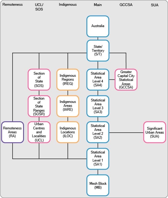
To ensure that all data released for dissemination of statistics can be comparable, the ABS publishes data using the Australian Statistical Geography Standard (ASGS) framework. The ASGS framework brings together all ABS geographies and regions into one integrated geospatial standard that enables organisations to collect, analyse and visualise ABS data.
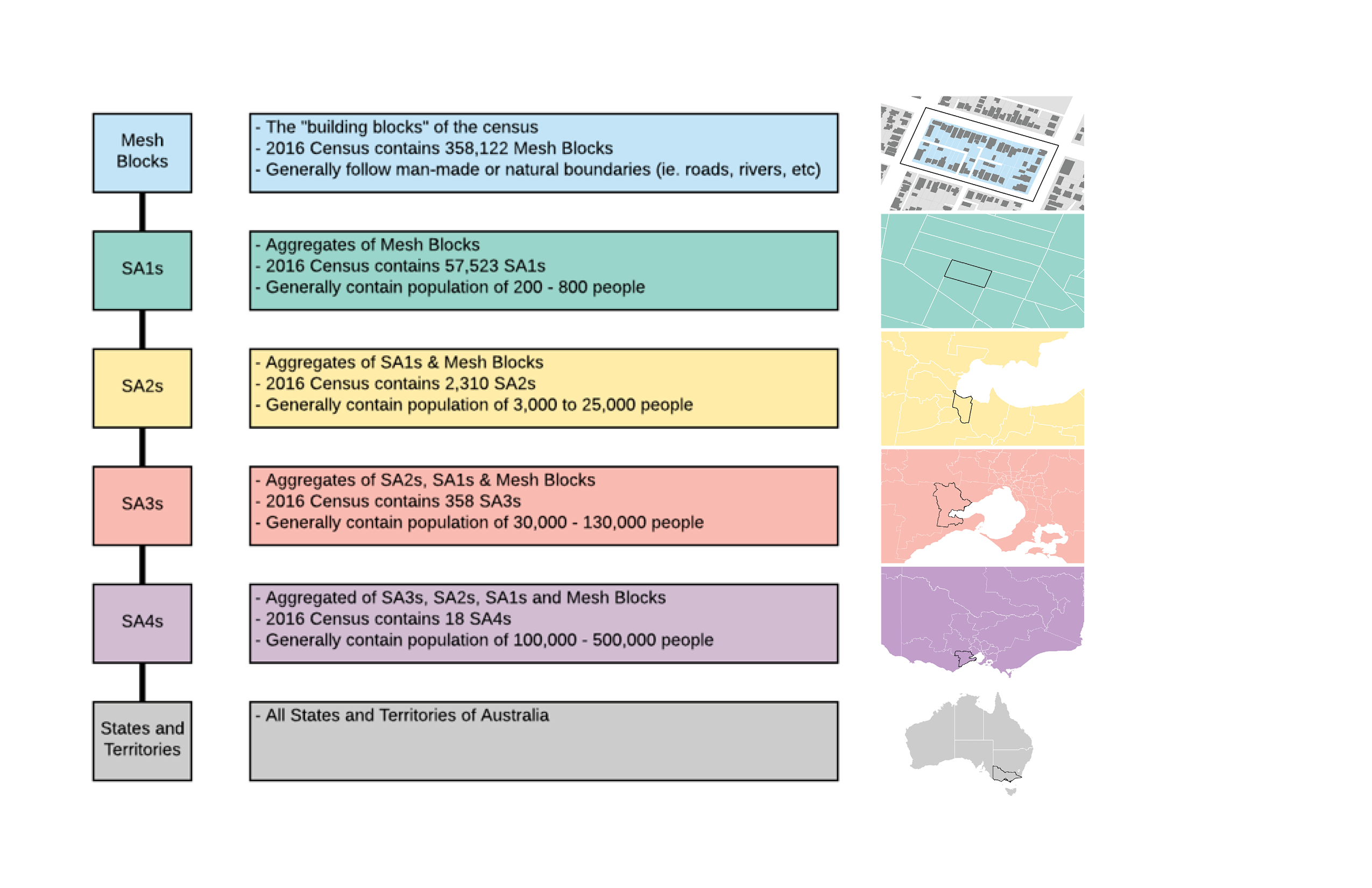
Each geography has unique granularity and the census data is aggregated and reported for these spatial areas across the country. The following table highlights the different types of geographies and what data is released in each.
What is released and when?
The ABS will release the census data progressively over the next 6 months with each release containing more detailed information than the last. Below are some key data release dates:
| Date | What’s being released | Minimum ABS Geography |
| 27 June, 2017 | Census of Population and Housing of Australia 2016 (first release)
General Community Profile Time Series Profile |
Statistical Area Level 2 (SA2) |
| 4 July, 2017 | Mesh Block Counts. Only basic person and dwelling counts will be available. | Mesh Block |
| 12 July, 2017 | Census Data Packs (first release)
General Community Profile (Population & Housing) Time Series Profile Place of Enumeration Profile This data is only available from State level down to SA2 (no longer SA1) |
Statistical Area Level 1 (SA1) |
| 17 October 2017 | Detailed Census data on employment, qualifications and population mobility | Statistical Area Level 1 (SA1) |
| 2018 | Socio-Economic Indexes for Areas | Statistical Area Level 1 (SA1) |
Spatial Vision has been maximising the power of ABS data for our clients since 1999. We integrate geographic and organisational data to provide business systems, spatial analyses and custom solutions to address some of the most pressing resource, economic and environmental challenges.
Our solutions underpin the effective management of demographic information, built assets and infrastructure as well as natural resources. Many of the projects we have delivered for our clients have received state, national and international awards recognising their contribution to industry best practice.
You can find our more information about the ABS release dates here
A certified GIS Professional with over 15 years of experience, Geoff has extensive experience in the management of multi-disciplinary project teams and the design and production of spatial analytics and mapping across a broad range of areas and themes.While delivering complex GIS analysis and output mapping on major infrastructure projects nationally, Geoff is also responsible for managing the production of Emergency services mapping products along with other award winning commercial mapping products under the SVmaps brand.
- SV Maps Goes Digital - March 12, 2021
- The Importance of Accreditation in the Spatial Industry - October 5, 2018
- Updating the Victorian State Command Centre Wall Map - December 12, 2017