Meet Imran Qazi General Manager of Lapis IT
Meet Geoff Williams General Manager of Spatial Services & Products
Spatial Vision – Paving the way for positive change
Spatial Vision – Our Foundation Story
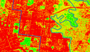
Harnessing Earth Observation (EO) to Build Climate Resilience in Urban Areas
GIS Training – Creating a sustainable skills ecosystem
Our 2024 Pacific Islands Geospatial Skills Program Candidate
Spatial Vision is a carbon neutral organisation
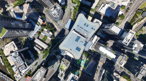
Getting the most out of your GIS strategy & investment
Climate Change & Homelessness: Understanding the Connection