Unlocking the Geospatial Potential of Water Authorities
Knowing the location of assets, customers and water resources are crucial for the effective operation of water utilities. Geospatial capabilities including GIS play an increasingly vital role in supporting Australian water utilities but their value extends well beyond the location of assets and customers.

The 2024 National Water Industry GIS Capability Report highlighted the benefits now derived from the savvy use of GIS including climate change planning, emergency management, network performance management, customer service and strategic planning.
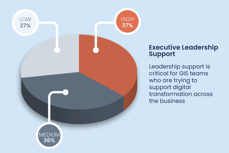
Executive Endorsement Crucial to Success
It is encouraging to see that over 70% of senior leadership are supporters of GIS, with an increasing number highly supportive. The new generation of leadership are expecting to have access to data to support their decisions.
Missing Opportunities in the Cloud
Nearly 70% of surveyed water authorities use on-premise infrastructure to host their corporate web-GIS. While some authorities indicated that cloud hosting is under review, this is a low number when compared to other businesses in Australia. A 2024 survey of Australian business reports over 60% of businesses have already transitioned to the cloud. It is likely that there are some efficiencies to be had by planning for a successful transition into the cloud in the near term.
Another challenge facing the GIS professionals working in the water industry was a lack of resources, summed up by this poignant statement from one survey participant. “The opportunities for GIS into the future are almost endless but I’m currently too busy with ‘business-as-usual’ to spend time trying to justify and implement new initiatives.”
Seizing the Benefits of Drone Technology
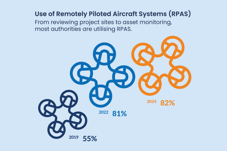
The use of Remotely Piloted Aircraft Systems (RPAS) has matured over the past five years. The adoption of geospatially informed, real-time monitoring of operations is a powerful enabler for many authorities. Given that an Uncrewed Aerial Vehicle (UAVs) or drones can capture data from the field 30 times faster and more easily than traditional onsite surveying or in person inspection methods, it’s not surprising that their use is now embraced in many organisations.
The use is only slightly up from 2022, with 82% of respondents using drones in some capacity. Respondents noted that the most common reason for using drones is to review site work and to capture imagery, with some also finding value for OHS surveys, detection of thermal leaks and weed control.
Informing Climate Change Planning & Action
There are increasing expectations that water authorities will identify the potential risks and opportunities that climate change will present as extreme weather events increase in volume and severity. Holding reliable location data on assets, their characteristics and customer needs, future demand forecasts will be crucial to making informed decisions to reduce the risk and impact of climate on water supply. It is encouraging to see that already ~25% are directly building the capability to inform decision making using geospatial, while nearly 40% are planning to do so in the near term.
Proudly Supporting the Water Industry
The outcomes from the 2024 National Water Industry GIS Capability Report were discussed at the recent GIS Water User Group (GWUG) hosted by Spatial Vision, and one participant highlighted, “there is no single way to approach spatial solutions – each organisation is unique”.
Participants remarked that their individual GIS Capability Reports would assist them in several ways including, contributing to digital transformation program priorities, planning future projects, identifying industry trends and highlighting business drivers.
They also mentioned that it was beneficial to be able to benchmark themselves against the progress of other authorities and understand how others were performing.
Digital transformation is a journey, in which modern geospatial capabilities are a key enabler. Success is often driven by champions and those willing to explore opportunities and innovation.
Spatial Vision has provided support and solutions to water authorities for over 20 years and we’re proud to support the GIS champions in the Australian water industry by producing the annual National Water Industry GIS Capability Reports and hosting the GWUG. We provide these resources to assist this professional community – helping them create new opportunities, share their successes, ask questions and discuss challenges as passionate advocates for progress.
To download a copy of the Water Authorities National Geospatial Capability Report, complete the form below.


