• About
    • Our Company
    • Our Board
    • Our People
    • Work With Us
    • Partners
  • Services
    • Strategic Consulting
    • Spatial Data Analysis
    • GIS Services & Support
    • Enterprise GIS Services
    • Visualisation & Mapping
    • Application Development
    • GIS Training
  • Industries
    • Climate Change
    • Agriculture
    • Natural Resource Management
    • Fisheries and Marine
    • Water Utilities
  • Library
    • Case Studies
    • Blog
    • News
    • Climate Action Barometer Report 2024/2025
  • About
    • Our Company
    • Our Board
    • Our People
    • Work With Us
    • Partners
  • Services
    • Strategic Consulting
    • Spatial Data Analysis
    • GIS Services & Support
    • Enterprise GIS Services
    • Visualisation & Mapping
    • Application Development
    • GIS Training
  • Industries
    • Climate Change
    • Agriculture
    • Natural Resource Management
    • Fisheries and Marine
    • Water Utilities
  • Library
    • Case Studies
    • Blog
    • News
    • Climate Action Barometer Report 2024/2025
Get in touch

Solutions:

Digital Cadastre Transformation

Transformation of the spatial element of a Cadastre, with “parcels” being one of the global fundamental data themes, is vital to support many of the digital infrastructure initiatives and growth and development strategies being pursued by governments around the world. Our cadastre transformation solutions for digital cadastres are underpinned by the deep technical expertise necessary to bring property boundaries into the digital age.

Our dedicated team of cadastral technicians employ highly automated open-source solutions and has depth of experience in cadastre transformation and adjustment. We work closely with government agencies and other stakeholders to transform the spatial representation of land and property boundaries into accurate, reliable digital resources delivering tangible social, economic and environmental benefits, in addition to saving cost and time in the transformation process.

Victoria’s Digital Cadastre Modernisation Project

Stage 2: Adjustment

Reliable digital cadastral mapping is fundamental to economic growth and sustainability.

Victoria’s digitalised cadastre will deliver significant productivity gains across many sectors of the economy – from property and land development, through to utility and other infrastructure asset management. It will underpin $81 billion (AUD) in new infrastructure investment and the development of capabilities like digital survey plan lodgement, Victoria’s Digital Twin and the development of a 3D cadastre for the State

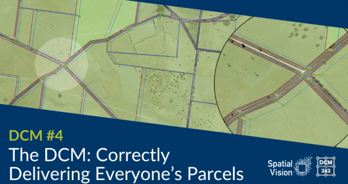
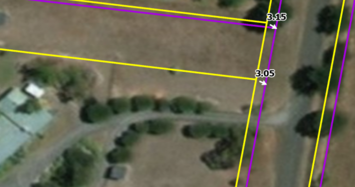
For some time the Victorian government recognised the limitations of the State’s existing cadastral mapping and the need to improve its accuracy for use in a wide range of modern applications. Developed over the past 30 years from digitised survey plan boundaries, inconsistent accuracy was widespread due to using various sources.

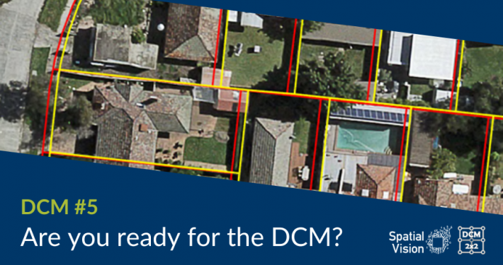
The Government’s goal was to recreate a new Victorian digitalised cadastre entailing the transformation of approximately 850,000 survey plan PDFs (describing some 3.3 million parcels) by capturing the plan measurements and using a least squares adjustment process to derive a more accurate data-driven digital cadastral representation. These plans ranged from historic (some over 150 years old) to modern. Hence, they were impacted by a wide range of survey instruments, observation types and regulatory conditions.

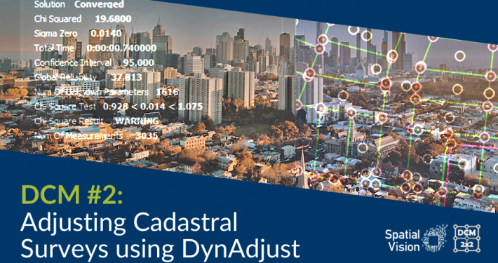
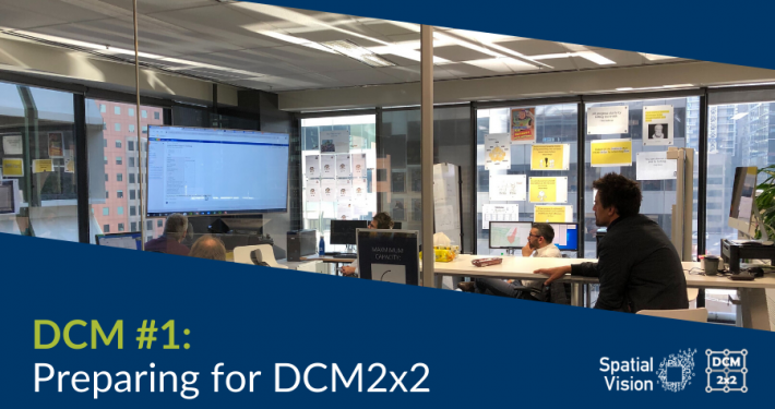
Spatial Vision’s role is leading the significant Adjustment Services stage of Victoria’s $45 million four-stage Digital Cadastre Modernisation project (with partners Reeds Consulting and Collier Geodetic Solutions). This has required building an automated adjustment engine using open-source software components, a team of skilled operators and by working closely with our Government client and local surveying experts. The articles below provide greater insight into the challenging process which was awarded for Technical Excellence by APSEA in 2022.

Digital Cadastre Modernisation

July 23, 2024
Spatial Vision has the experience and tools to assist with digital cadastral improvement projects with our proven open source-based digital Cadastre Adjustment Toolkit developed for Victoria's ground-breaking Digital Cadastre Modernisation of over 3.3 million land parcels.
Read more
https://spatialvision.com.au/wp-content/uploads/2022/09/DCM-example.png 914 1371 Samantha Sinclair https://spatialvision.com.au/wp-content/uploads/2020/04/SV_Logo_Inline.png Samantha Sinclair2024-07-23 04:37:162024-07-23 16:37:11Digital Cadastre Modernisation

Case Study: Victoria’s Digital Cadastre Modernisation

September 11, 2023
Spatial Vision played a key role in the digitisation and alignment Victoria’s property boundaries to produce a more accurate “single source of truth”, reducing costs and boosting productivity across both the public and private sectors, as well as increasing information accessibility.
Read more
https://spatialvision.com.au/wp-content/uploads/2023/08/Case-Study-web-tile.png 500 900 Samantha Sinclair https://spatialvision.com.au/wp-content/uploads/2020/04/SV_Logo_Inline.png Samantha Sinclair2023-09-11 09:20:262023-12-20 11:04:32Case Study: Victoria’s Digital Cadastre Modernisation
APSEA Award Technical Excellence Locate Digital Cadastre Modernisation

Spatial Vision takes out national APSEA Award

May 12, 2023
The enormous efforts of our Digital Cadastre Modernisation team, including our project partners DTP, Reeds Consulting, Collier Geodetic Solutions, Jacobs and DSM SOFT PVT LTD, were recognised last night in Adelaide with the APSEA Award for Technical Excellence.
Read more
https://spatialvision.com.au/wp-content/uploads/2023/05/DC-award-scaled.jpg 1707 2560 Samantha Sinclair https://spatialvision.com.au/wp-content/uploads/2020/04/SV_Logo_Inline.png Samantha Sinclair2023-05-12 12:16:012024-11-14 11:16:09Spatial Vision takes out national APSEA Award

Are you ready for DCM?

November 25, 2022
The Digital Cadastre Modernisation project (also known as DCM), is here. It is a major update to the Victorian State Governments managed property dataset. The Department of Environment, Land, Water and Planning (DELWP) have started to release the first few updates to the new cadastre.
Read more
https://spatialvision.com.au/wp-content/uploads/2022/11/DCM-Blog-Covers-3.png 506 900 Samantha Sinclair https://spatialvision.com.au/wp-content/uploads/2020/04/SV_Logo_Inline.png Samantha Sinclair2022-11-25 16:01:272023-12-20 11:14:02Are you ready for DCM?

Spatial Vision on the double at Vic APSEA Awards

October 28, 2022
Spatial Vision are honoured to have won Victorian APSEA Awards for both our nominated projects - Victoria's Digital Cadastre Modernisation and the Surface Permeability Analysis of Elster Creek Catchment.
Read more
https://spatialvision.com.au/wp-content/uploads/2022/10/SV-wins.jpg 800 1200 Samantha Sinclair https://spatialvision.com.au/wp-content/uploads/2020/04/SV_Logo_Inline.png Samantha Sinclair2022-10-28 15:40:132024-11-14 11:21:08Spatial Vision on the double at Vic APSEA Awards

The DCM Project – Correctly Delivering Everyone’s Parcels

August 8, 2022
“Everyone’s motivated to perform their bit for this innovative project. The team is also a firm believer of continuous improvement, so while our processes now are streamlined, it continues to evolve.” –Ryanne Firme, DCM Production Manager
Read more
https://spatialvision.com.au/wp-content/uploads/2022/07/DCM-Blog-4.png 497 885 Samantha Sinclair https://spatialvision.com.au/wp-content/uploads/2020/04/SV_Logo_Inline.png Samantha Sinclair2022-08-08 09:49:112023-12-20 11:16:15The DCM Project – Correctly Delivering Everyone’s Parcels

Vicmap Users to Benefit from New DCM Tools & Resources – Digital Cadastre Modernisation (DCM)

March 18, 2022
The project delivers a toolkit of resources for organisations to plan for and undertake the adoption of the DCM adjusted Vicmap data.
Read more
https://spatialvision.com.au/wp-content/uploads/2021/10/DCM-Readiness-Index.png 1124 1148 Samantha Sinclair https://spatialvision.com.au/wp-content/uploads/2020/04/SV_Logo_Inline.png Samantha Sinclair2022-03-18 10:34:012023-12-20 11:16:56Vicmap Users to Benefit from New DCM Tools & Resources – Digital Cadastre Modernisation (DCM)

DCM #3: Process, progress & building a world-class team

November 17, 2021
“The work we are doing on the DCM project has never been done before leaving an open door for innovation, problem solving, and the delivery of a world leading product. With a strong appreciation for the Victorian cadastre, this is our contribution to supporting its development, while leaving a legacy.” –Cameron Hamilton, DCM Adjustment Team Leader
Read more
https://spatialvision.com.au/wp-content/uploads/2021/11/DCM-Blog-3-Cover.png 506 900 Jeremy Alcorn https://spatialvision.com.au/wp-content/uploads/2020/04/SV_Logo_Inline.png Jeremy Alcorn2021-11-17 12:30:472024-10-08 10:22:02DCM #3: Process, progress & building a world-class team

Welcome Ryanne Firme – Digital Cadastre Modernisation Team

May 21, 2021
Spatial Vision is pleased to announce the appointment of Ryanne Firme as Production Manager of our Digital Cadastre Modernisation project team.
Read more
https://spatialvision.com.au/wp-content/uploads/2021/05/Ryanne-Featured-Image-1.png 862 1384 Spatial Vision https://spatialvision.com.au/wp-content/uploads/2020/04/SV_Logo_Inline.png Spatial Vision2021-05-21 14:27:362024-10-11 14:09:57Welcome Ryanne Firme – Digital Cadastre Modernisation Team

Welcome Stephen Boothroyd – Digital Cadastre Modernisation Team

April 13, 2021
Spatial Vision welcomes Stephen Boothroyd as our Quality Assurance Manager for the Digital Cadastre Modernisation (DCM) project.
Read more
https://spatialvision.com.au/wp-content/uploads/2021/04/stephen-welcome-featuredimage.png 862 1384 Spatial Vision https://spatialvision.com.au/wp-content/uploads/2020/04/SV_Logo_Inline.png Spatial Vision2021-04-13 14:59:262024-10-11 14:09:37Welcome Stephen Boothroyd – Digital Cadastre Modernisation Team

DCM #2: Adjusting Cadastral Surveys using DynAdjust

October 26, 2020
DCM Team Leader Jeremy Alcorn provides an introduction to DynAdjust, the tool being used to undertake least squares cadastral adjustments for the Digital Cadastre Modernisation project.
Read more
https://spatialvision.com.au/wp-content/uploads/2020/10/DCM-Blog-Cover-2.png 506 900 Jeremy Alcorn https://spatialvision.com.au/wp-content/uploads/2020/04/SV_Logo_Inline.png Jeremy Alcorn2020-10-26 15:55:502023-12-20 12:08:52DCM #2: Adjusting Cadastral Surveys using DynAdjust

DCM #1: Preparing for DCM2x2

June 19, 2020
Spatial Vision and partners Reeds Consulting and Collier Geodetic Solutions commence the Adjustment phase of DELWP’s Digital Cadastral Modernisation (DCM). In this first blog, Jeremy introduces the project team and objectives.
Read more
https://spatialvision.com.au/wp-content/uploads/2020/06/BlogCover1.png 506 900 Jeremy Alcorn https://spatialvision.com.au/wp-content/uploads/2020/04/SV_Logo_Inline.png Jeremy Alcorn2020-06-19 17:45:232024-11-12 15:53:26DCM #1: Preparing for DCM2x2

Spatial Vision to Play a Key Role in Victoria’s Digital Cadastre Modernisation

June 16, 2020
Spatial Vision is pleased to announce that it will lead the Adjustment Services stage of Victoria’s Digital Cadastre Modernisation Project. Spatial Vision is working in collaboration with Reeds Consulting and Collier Geodetic Solutions for this project.
Read more
https://spatialvision.com.au/wp-content/uploads/2020/06/dcm.jpg 540 960 Spatial Vision https://spatialvision.com.au/wp-content/uploads/2020/04/SV_Logo_Inline.png Spatial Vision2020-06-16 13:51:002023-12-20 12:11:13Spatial Vision to Play a Key Role in Victoria’s Digital Cadastre Modernisation
PreviousNext

OUR PARTNERS

Reeds Consulting is one of the state’s leading survey consulting companies and a strategic partner of Spatial Vision. Phil Collier of Collier Geodetic Solutions has extensive experience as an educator, researcher and developer. Areas of expertise include geodesy and precise GNSS with a focus on applying advanced measurement and numerical analysis techniques to the solution of practical, spatial problems. Our combined expertise forms the basis of our robust cadastre transformation capability.

{"infinite":"true","pause_on_hover":"true","adaptive_height":"false","items":"2","auto_play":"true","speed":"4000","rtl_mode":"false","dots":"false","dots_mobile":"false","nav":"false","nav_mobile":"false","slides_to_scroll":"1","slides_to_scroll_mobile":"1","lcp_row":"1","auto_play_speed":"2000","draggable":"true","swipe":"true","lazy":"false","carousel_mode":"standard","center_mode":"false","center_mode_padding":"60px","vertical":"false","nav_type":"nav_arrow","items_desktop":"2","items_desktop_small":"2","items_tablet":"2","items_mobile":"2","nav_arrow_type_horizon":"angle_arrow_horizon"}
Reeds Consulting
Collier Geodetic Solutions

Join Our Newsletter

Subscribe to our newsletter for the latest insights, news, and updates.

We are based in Melbourne and provide services and products throughout Australia, New Zealand and other overseas countries.
Level 8, 575 Bourke Street
CBD VIC 3000
Melbourne, Australia
Linkedin Facebook-f X-twitter
Get in touch
We acknowledge the Traditional Custodians of the land on which we meet today, the Wurundjeri and Boon Wurrung peoples of the Kulin Nation, and pay our respects to their Elders, past, present.