Dja Dja Wurrung QField Solution
Drone Rules Map For Public Use
Enterprise Spatial Data Platform Transformation
GIS Service Plan – Melton City Council
NPWS Procurement Roadmap
SPREP MMEL Climate Resilience Support Tool
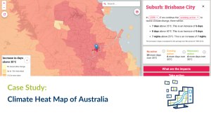
Climate Heat Map of Australia
Migratory Birds As Connectivity Indicators
Melbourne Metropolitan Open Space 30–Year Investment Opportunities Framework
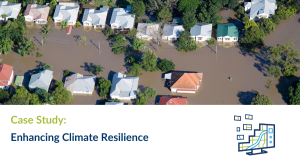
Case Study: Enhancing Climate Resilience