Harnessing Earth Observation (EO) to Build Climate Resilience in Urban Areas
As our climate continues to change at an unprecedented pace, the need to adapt and mitigate its effects becomes increasingly urgent. Building resilient communities is no longer just an option – it’s a necessity. One of the most promising tools in this endeavour is Earth Observation (EO), which plays a critical role in monitoring environmental changes and guiding actions to counteract the adverse effects of climate change.
Understanding Earth Observation (EO)
Earth Observation refers to the collection and analysis of data about the Earth’s atmosphere, lands, and oceans via airborne and satellite remote sensing platforms. This data, often made freely available by initiatives like the Copernicus program from the European Union Space Agency (ESA) and the United States Geological Survey (USGS) through their Sentinel and Landsat missions, provide invaluable insights into how our environment is changing.
The Power of EO in Urban Resilience
One of the most impactful applications of EO is in mapping and analysing tree canopy and vegetation cover within urban environments. These processes are essential for tracking the effects of climate change on our cities over time. By understanding changes in vegetation and green spaces, we can develop strategies to enhance urban resilience, particularly in the face of increasing temperatures and the Urban Heat Island (UHI) effect.
Vegetation Indices: Key Metrics for Climate Action
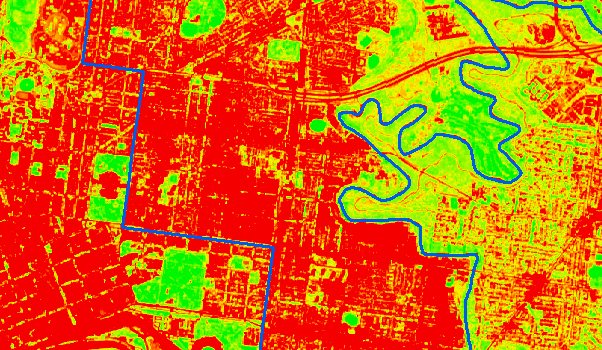
Vegetation indices (VIs) derived from EO imagery are powerful tools for assessing the health and density of vegetation. For example, the Normalised Difference Vegetation Index (NDVI) uses spectral data from the Red (RED) and Near Infrared (NIR) bands to quantify vegetation greenness. This data can help us understand the distribution of vegetation, its health, and how it is changing over time – a critical factor in urban planning and climate adaptation efforts.
In conjunction with other metrics, such as Land Surface Temperature (LST), which uses thermal imagery to assess land heat emissivity, VIs can offer a comprehensive view of how urban environments are being impacted by climate change. By analysing these metrics, we can identify areas most in need of greening and cooling initiatives, such as regions with dense infrastructure and limited vegetation.
Practical Applications for Urban Planning
The insights gained from EO and related indices are particularly valuable for urban planners and decision-makers. In Victoria, for example, several councils, including the City of Yarra, City of Greater Geelong, and City of Melbourne, have implemented urban forest strategies aimed at combating climate change. By leveraging EO data, these councils can develop adaptive, sustainable urban greening strategies and monitor their effectiveness over time.
The Multifaceted Benefits of Greening Urban Spaces
Increasing tree canopy and vegetation cover in urban areas offers numerous benefits. Most importantly, it mitigates the UHI effect, reducing temperatures in areas where heat is most concentrated. This not only protects infrastructure from heat-related damage but also improves public health by reducing the incidence of heat-related illnesses.
Enhanced green spaces also contribute to biodiversity, providing habitats for local wildlife and creating a more resilient ecosystem. Native plants, play a crucial role in supporting local species and building an environment that can better withstand climatic changes.
Finally, the aesthetic and psychological benefits of green urban spaces should not be overlooked. Moving away from the “concrete jungle” concept, these areas make cities more attractive, liveable, and enjoyable for residents and visitors alike.
Conclusion
Incorporating EO into urban planning is not just about adapting to climate change – it’s about proactively building communities that are resilient, healthy, and vibrant. By utilising EO data to inform strategies for greening and cooling our cities, we can ensure that our urban environments remain sustainable and liveable for future generations.

